Navigation Menu

Te Matau-a-Māui (Separation Point)

Te Matau-a-Māui (“the hook”) is the easternmost point of Golden Bay and the western tip of Tasman Bay.

A pā, kāinga and fishing complex occupied much of the peninsula at Te Matau-a-Māui and this is the burial place of the rangatira Tūtepourangi (he rangatira mana nui).

It has added significance for Ngāti Apa (and Ngāti Kuia) because it was the western boundary of the tuku of Tūtepourangi.

More Information»

Moutere Inlet 

The Moutere Inlet was another important source of kaimoana. The hull of Te Awatea, the waka that had brought many Ngāti Apa tīpuna to Te Tauihu, was stored for many years in a cave at Te Mamaku, on the northern end of the Moutere Bluff near Motueka.

More Information»

Matangi Āwhio (Auckland Point) 

Matangi Āwhio consisted of a large pā and kāinga complex overlooking a beach where waka could be safely landed.

Extensive racks used for net repair and drying fish were a notable feature of this place.

Further Ngāti Apa pā, kāinga and fishing stations could be found all along the eastern coast of Te Tai Aorere. Among the most important of these was Waimea, renowned for its kaimoana and extensive gardens.

More Information»

Kawatiri (Buller)

The Kawatiri awa sat within a complex series of pathways and trails and a number of Ngāti Apa pā, cultivations, mahinga kai, and urupā were located on the river.

The tīpuna Takapau and Tamahau were born and died here. Takapau was kaitiaki of the gardens at Kawatiri, as stated: “Nōna i whakamara ngā mahinga kai o te hapū whānau o Ngāti Apa”.

Pou-o-te-Rangi and Tureia, descendants of Takapau, lived and died at Kawatiri.

Kawatiri was also a residence of the tīpuna Te Rato (also known as Te Kōtuku, the White Heron), Te Whare Kiore (who was killed here during the northern invasions), Mahuika, and the high-born woman Mata Nohinohi. Mata Nohinohi was the mother of Kehu, the famous Ngāti Apa/Tūmatakōkiri guide and kaitiaki of the inland trails and Mahuika. The tipuna Pūaha Te Rangi, a participant in the 1860 Arahura Purchase, was another rangatira associated with Kawatiri. The tipuna Kuneoterangi is buried there.

A kāinga on the river was re-occupied by Ngāti Apa after peace was established in the mid-1840s. Its leader was Mahuika, half-brother of Kehu and son of Mata Nohinohi.

More Information»

Kawatiri (Buller) River and its tributaries (northern portion) 

For centuries, the Kawatiri has been, and continues to be, an important mahinga kai, its pure water abundant in fish such as kōkopu, tuna, inanga, kahawai, kekewai and kōura. It was also a rich source of birds such as kākā, kererū, kākāpō, kiwi and weka.

The Kawatiri sat within a complex series of pathways and trails and a number of Ngāti Apa pā, cultivations, mahinga kai, and urupā were located on the river. The tīpuna Takapau and Tamahau were born and died here. Takapau was kaitiaki of the gardens at Kawatiri, as stated: “Nōna i whakamara ngā mahinga kai o te hapū whānau o Ngāti Apa”.

Pou-o-te-Rangi and Tureia, descendants of Takapau, lived and died at Kawatiri.

Kawatiri was also a residence of the tīpuna Te Rato (also known as Te Kōtuku, the White Heron), Te Whare Kiore (who was killed here during the northern invasions), Mahuika, and the high-born woman Mata Nohinohi. Mata Nohinohi was the mother of Kehu, the famous Ngāti Apa/Tūmatakōkiri guide and kaitiaki of the inland trails and Mahuika. The tipuna Pūaha Te Rangi, a participant in the 1860 Arahura Purchase, was another rangatira associated with Kawatiri. The tipuna Kuneoterangi is buried there.

A kāinga on the river was re-occupied by Ngāti Apa after peace was established in the mid-1840s. Its leader was Mahuika, half-brother of Kehu and son of Mata Nohinohi.

More Information»

Tākaka River

An ancient summer trail follows the course of the Tākaka River from the river mouth to Cobb Valley to the Wangapeka track. This linked the southern end of Golden Bay with the West Coast and Kawatiri. The Cobb Valley limestone caves were used by Ngāti Apa tīpuna as urupā and remain tapu today.

Ngāti Apa lived in a series of pā and kāinga along the Tākaka and valued the Tākaka as an important mahinga kai. Its pure water was once abundant in fish such as upokorokoro (grayling or native trout), as well as inanga, kōkopu and tuna; and birds such as kererū, kiwi, kākāpō, weka, korimako (bellbird) and kōkō (tūī). There were also extensive Ngāti Apa cultivations associated with the river.

More Information»

Te Motupiko (Motupiko River)

An ancient trail follows the course of the Motupiko and Motueka Rivers from Mangatāwhai, or “The Place of Many Trails‟ (Tophouse, near the Nelson Lakes). This formed the main track linking Mohua (Golden Bay) and Te Tai-o-Aorere (Tasman Bay) with the Wairau and Kawatiri areas.

A series of Ngāti Apa pā, kāinga, mahinga kai (especially birding areas) and cultivations are associated with the Motupiko River.

Ngāti Apa valued Te Motupiko as an important mahinga kai. Its pure water was abundant in fish such as upokorokoro (grayling or native trout), as well as inanga, kōkopu and tuna (eels); and birds such as kererū and kōkō (tūī). Some of these are now virtually extinct as a result of the effects of settlement, river diversion and pollution.

More Information»

Te Waimea (Waimea River)

Ngāti Apa valued Te Waimea as an important mahinga kai. Its pure water was abundant with fish such as mako and pātiki in the estuarine waters at the mouth of the river, as well as kōkopu, inanga, kahawai, kekewai and kōura, and a rich source of birds such as kākā, kererū and kōkō (tūī). The river environs were also a good source of flax, and clay used in the process of drying the flax came from the river near the inland foothills of the ranges.

Te Waimea also formed a water source for the renowned Waimea gardens, located at the mouth of the Waimea River adjacent to a pā and kāinga complex. Smaller “satellite” pā were located elsewhere on the banks of the river and at the junction of the Wairoa and Wai-iti rivers. This was a site of great significance to Ngāti Apa and the other Kurahaupō iwi.

Around 1000 acres of cultivation located near the river mouth represent generations of sustained effort by the tīpuna. The cultivation land was built up with ash (to provide potash and lime), gravel and fine sand and silt to raise soil temperatures and was highly suitable for kūmara production. The modified soil remains darker and more productive than surrounding soil to this day. Huge pits nearby reveal the source of gravel. The extent of these gardens and the effort involved in creating them indicates that the area was once occupied by a substantial population.

Early chiefs of this place were Te Hāpuku and Te Pipiha. The latter was killed here during the northern invasions. Other tīpuna associated with Waimea were Titiko and Whakatapihi. After the northern invasions many tīpuna from the pā moved to another pā in what later became known as Budges Bush, in the Wairoa River Valley on the north slope of Mount Heslington.

Ngāti Apa were among those who continued to cultivate and occupy the land until at least the mid-1840s, when produce grown in the extensive gardens was traded with the Nelson settlers at a market in the town at Matangi Āwhio (Auckland Point). Waimea was a residence of the tipuna Meihana Kereopa at this time.

More Information»

Toropuhi

A pā was located at Toropuhi, south of Big Bay. Weka was the chief here at the time of the northern invasions.

More Information»

Patuarau

Patuarau, at the mouth of the river of the same name, was a kāinga, cultivation site and fishing station important to Ngāti Apa ki te Rā Tō tīpuna.

More Information»

Parapara (Parapara Inlet)  

Parapara Inlet contained a pā, kāinga and fishing station. Parapara was also home to the celebrated taniwha Kai Whakaruaki, who was ultimately was destroyed by Ngāti Apa warriors, assisted by other southern iwi.

Other pā sites were Puramahoi, Taupō Point and Pungarau-Whiti.

More Information»

Pākawau

Pākawau was an important fishing station for Ngāti Apa and was guarded by a pā.

More Information»

Pūponga

Two Ngāti Apa pā were located at Pūponga, an important shark fishery.

More Information»

Whanganui Inlet

Whanganui Inlet was a particularly significant site, containing two pā (Te Awaturoto and Taurangahioi). Important Ngāti Apa tīpuna who lived at Whanganui were Te Kōtuku, Te Whio, Paihora, Matiaha Tumaunga, Matimati, Tumanga, Meihana Kereopa and his mother Kerenapu and Wirihana Maui.

The renowned Ngāti Apa tipuna Te Kōtuku was killed at Te Awatūroto, and his korowai named Te Rarawa was taken.

The tipuna Te Whio was also killed at Whanganui Inlet. Tipuna Paihora was killed at Taurangahioi. Other Ngāti Apa chiefs who resided in the area were Matiaha Tumaunga, Aperahama Matimati, Heni Tumanga, Meihana Kereopa and his mother Kerenapu, and Wirihana Maui.


More Information»

Westhaven Wildlife Management Reserve 

For centuries Ngāti Apa have been born and raised at Te Taitapu.

Ngāti Apa intermarried with the people they found in western Te Tauihu (Ngāti Tūmatakōkiri). Occupation areas were set up and maintained by Ngāti Apa around important mahinga kai areas of Te Taitapu, such as the estuarine areas of Paturau, Whanganui and along the coastline. Pahi (seasonal and temporary huts) were also set up in inland areas for hunting, gardening and food gathering.

Pā sites, kāinga, urupā and cultivation areas included Te Awatūroto and Taurangahīoi at Whanganui Inlet. The renowned Ngāti Apa tipuna Te Kōtuku was killed at Te Awaturoto, and his korowai named Te Rarawa was taken. The tipuna Te Whio was also killed at Whanganui Inlet. The tipuna Paihora was killed at Taurangahioi. Other Ngāti Apa chiefs who resided in the area were Matiaha Tumaunga, Aperahama Matimati, Heni Tumanga, Meihana Kereopa and his mother Kerenapu, and Wirihana Maui. Two pā (first occupied by Ngāti Tūmatakōkiri) were located at Pūponga Point.

This area was an important shark fishery and a source of quartzite used for the manufacture of tools. A major iron ore deposit at Parapara provided kōkōwai (red ochre) for local use and trade. Clay containing the necessary silicates was dried and ground, then mixed with fish or whale oil or a substance obtained from pitoko (tītoki) seeds to create ochre of high quality. Ochre was used as personal decoration and to decorate and protect waka and carvings.


More Information»

Te Taitapu (Westhaven) Marine Reserve 

Ngāti Apa have an association with Te Taitapu stretching back several hundred years. For centuries, Ngāti Apa have been born and raised at Te Taitapu. Our links with what is now known as the Heaphy Track are particularly strong, and are associated with tipuna Kehu.

Ngāti Apa intermarried with the people they found in western Te Tauihu (Ngāti Tūmatakōkiri). Occupation areas were set up and maintained by Ngāti Apa around important mahinga kai areas of Te Taitapu, such as the estuarine areas of Paturau, Whanganui and along the coastline. Pahi (seasonal and temporary huts) were also set up in inland areas for hunting, gardening and food gathering.

Pā sites, kāinga, urupā and cultivation areas included Te Awatūroto and Taurangahīoi at Whanganui Inlet. The renowned Ngāti Apa tipuna Te Kōtuku was killed at Te Awaturoto, and his korowai named Te Rarawa was taken. The tipuna Te Whio was also killed at Whanganui Inlet. The tipuna Paihora was killed at Taurangahioi. Other Ngāti Apa chiefs who resided in the area were Matiaha Tumaunga, Aperahama Matimati, Heni Tumanga, Meihana Kereopa and his mother Kerenapu, and Wirihana Maui. Two pā (first occupied by Ngāti Tūmatakōkiri) were located at Pūponga Point.

This area was an important shark fishery and a source of quartzite used for the manufacture of tools. A major iron ore deposit at Parapara provided kōkōwai (red ochre) for local use and trade. Clay containing the necessary silicates was dried and ground, then mixed with fish or whale oil or a substance obtained from pitoko (tītoki) seeds to create ochre of high quality. Ochre was used as personal decoration and to decorate and protect waka and carvings.

Ngāti Apa believe that the spirits of their deceased ancestors travel along the coastline and mountains of Te Taitapu to Te One Tahua (Farewell Spit) on their journey to Hawaiki.

More Information»

Te Taitapu (Big River site)

Ngāti Apa have an association with Te Taitapu stretching back several hundred years. For centuries, Ngāti Apa have been born and raised at Te Taitapu. Our links with what is now known as the Heaphy Track are particularly strong, and are associated with tipuna Kehu.

Ngāti Apa intermarried with the people they found in western Te Tauihu (Ngāti Tūmatakōkiri). Occupation areas were set up and maintained by Ngāti Apa around important mahinga kai areas of Te Taitapu, such as the estuarine areas of Paturau, Whanganui and along the coastline. Pahi (seasonal and temporary huts) were also set up in inland areas for hunting, gardening and food gathering.

Pā sites, kāinga, urupā and cultivation areas included Te Awatūroto and Taurangahīoi at Whanganui Inlet. The renowned Ngāti Apa tipuna Te Kōtuku was killed at Te Awaturoto, and his korowai named Te Rarawa was taken. The tipuna Te Whio was also killed at Whanganui Inlet. Tipuna Paihora was killed at Taurangahioi. Other Ngāti Apa chiefs who resided in the area were Matiaha Tumaunga, Aperahama Matimati, Heni Tumanga, Meihana Kereopa and his mother Kerenapu, and Wirihana Maui. Two pā (first occupied by Ngāti Tūmatakōkiri) were located at Pūponga Point.

This area was an important shark fishery and a source of quartzite used for the manufacture of tools. A major iron ore deposit at Parapara provided kōkōwai (red ochre) for local use and trade. Clay containing the necessary silicates was dried and ground, then mixed with fish or whale oil or a substance obtained from pitoko (tītoki) seeds to create ochre of high quality. Ochre was used as personal decoration and to decorate and protect waka and carvings.

Ngāti Apa believe that the spirits of their deceased ancestors travel along the coastline and mountains of Te Taitapu to Te One Tahua (Farewell Spit) on their journey to Hawaiki.

More Information»

Te One Tahua (Farewell Spit)

Te One Tahua (the sandy bank) was the name given to this area by Ngāti Apa tīpuna. Ngāti Apa have an unbroken historical, traditional and spiritual association with Te One Tahua stretching back several hundred years.

Tīpuna occupied the coastline and inland area south of Te One Tahua for centuries. It is believed that the spirits of Ngāti Apa ancestors travelled from the mountains up the coastline to Te One Tahua on their journey to Hawaiki. Owing to the spiritual nature and significance of Te One Tahua to Ngāti Apa, specific tikanga and kawa were observed to enable safe travel or resource collection.

Te One Tahua was an important mahinga mātaitai (fishing area), giving access to tuatua and tuangi (cockles. Occupation areas and tauranga waka were set up and maintained around the landward end of Te One Tahua.

More Information»

Kaiteriteri Scenic Reserve 

Kaiteriteri lies at the centre of what was for several generations a large and intensive Ngāti Apa occupation and cultivation complex. This complex occupied a 10-kilometre stretch of coastline, including the current Kaiteriteri scenic reserve. It included up to eight pā, as well as associated kāinga, urupā, cultivations, mahinga kai areas and fishing stations.

Some of the more notable Ngāti Apa pā at Kaiteriteri were Kākā Island/Point, Puketāwai (located on Anawera Point just south of Kaiteriteri Beach on the headland separating Tapu Bay and Stephens Bay) and Mangatāwai. At Mangatāwai, Ngāti Apa tīpuna Te Rangihīroa and Koroneho Titi were captured after a battle with northern iwi. Komakorau, the son of Te Rato was killed by a northern taua at Puketāwai. Te Rato was one of the Ngāti Apa rangatira who met Captain Cook in Tōtaranui (Queen Charlotte Sound).

The cliffs at Ana-waka-ū contained burial caves, and a stream called Wai atau, running beside the cliffs, was a tauranga waka for Ngāti Apa. A Ngāti Apa urupā is located on the small islet at the northern end of the main Kaiteriteri beach.

More Information»

Te Taero a Kereopa (Boulder Bank) 

Tradition tells us that Te Taero a Kereopa was created after two of Kupe’s crew decided to stay in Te Waipounamu when they were due to leave for Te Ika-a-Māui (the North Island). With two wāhine, they stole a waka and set off. Kupe pursued them, but they recited karakia that caused rocks to fall and create a barrier between them and Kupe. This was the origin of the Te Taero a Kereopa, which was later visited by the tīpuna Tū Ariki, a great grandson of Ruatea, captain of the Kurahaupō waka. He captured a shark near the Boulder Bank and took it home to Whanganui. Here it grew into the famous taniwha Tūtaeporoporo.

More Information»

Tarakaipa Island

Tarakaipa is one of the largest islands in Tennyson Inlet. It was named after the Ngāti Apa tipuna Tarakaipa, a great-grandson of Tamahau and son of Rawaru. Tarakaipa was an important rangatira who was among the leaders of an early migration to Te Tauihu. He arrived in Te Tauihu on the sacred waka Te Awatea, built from a hull of the Kurahaupō waka. Tarakaipa is also the name of a hapū of Ngāti Apa ki te Rā Tō.

Tarakaipa was an important mahinga mātaitai (fishing area) for Ngāti Apa ki te Rā Tō, providing access to important moki and elephant fish breeding grounds.

The island contained a pā and kāinga/fishing station complex associated with these activities. It still contains a number of urupā and other spiritual sites that are connected to Ngāti Apa ki te Rā Tō people.

More Information»

Puhikererū (Mt Furneaux) 

The scared maunga of Puhikererū is also of great significance to Ngāti Apa ki te Rā Tō because of its association with Kupe.

Puhikererū overlooks Te Anamāhanga (Port Gore). Its name (“plume of the pigeon”) evokes the kererū that were found here, the appearance of the clouds as they come over the maunga, and also recalls a tipuna particularly associated with this place.

When Kupe came to Aotearoa, he brought two birds with him named Rupe and Kawau-a-toru. The task of these birds was, among other things, to seek out the fruits of the forest and determine currents. When Kupe settled at Rimurapa (Sinclair Head, on the northern shores of Te Moana o Ngā Raukawakawa), his birds flew to Te Waipounamu and alighted on Puhikererū. Rupe joined the local pigeons in feasting on the abundant forest food of the maunga and its environs, and never returned to Kupe.

Puhikererū was an important mahinga kai for Ngāti Apa ki te Rā Tō residing at Anamāhanga and elsewhere. It was a place where kererū could be found in abundance, feeding on karaka, miro and other berries.

More Information»

Te Anatohia (East Bay) 

Te Anatohia (East Bay) represents one of two tentacles of the great Te Wheke-a-Muturangi.

More Information»

Te Ope-a-Kupe  (Te Anamāhanga/Port Gore) 

Te Anamāhanga (The Twin Bays) was one of the two tentacles of Te Wheke-a-Muturangi, the great octopus killed by Kupe, the other being Te Anatohia (East Bay). It lies in the shadow of two significant maunga, Puhikererū (Mt Furneaux), named after a Kurahaupō tipuna, and Parororangi (Mt Stokes), named for a place in Hawaiki. Parororangi was (and is) an important weather indicator and both maunga were also used as navigation aids.

In the bay, Te Ope-a-Kupe was a turanga waka (landing place) used by generations of Ngāti Apa ki te Rā Tō and is the place where many important Ngāti Apa tīpuna first came ashore in Te Waipounamu. It was the residence of the notable Ngāti Apa tīpuna Tu Tonga, Hape, Kapa and Kaitangata.

According to tradition, Kupe landed here in his waka, Te Matahourua. Indentations on rocks were formed by Kupe’s footprints and he named the place Te Ope-a-Kupe (The Footprints of Kupe). Other Ngāti Apa migrations lead by tīpuna such as Te Kahawai, Te Āhuru and Kōtuku all used Te Ope-a-Kupe and resided in Te Anamāhanga.

Karaka trees at Te Anamāhanga are known to Ngāti Apa as Te Karaka o Kupe, because the famous navigator is believed to have introduced them.

The area was an important fishing area, providing access to kōura, pāua, karengo and kokapoko. It contains pā sites, cultivations, kāinga and urupā, wāhi tapu that are still important to Ngāti Apa ki te Rā Tō today.

During a visit here in 2016, a rōpū of Ngāti Apa ki te Rā Tō rangatahi were greeted by two kereru as they entered the bay. And as they made their way to Te Ope-a-Kupe, a shag flew down onto the rock, opening its wings as if to greet them. To commeorate this tohu, a new taiaha move was composed and named, Te Kaikau o te Kawau.


More Information»

Rotoiti

Ngāti Apa trace their earliest connection to Lake Rotoiti (small waters) from their ancestor Kupe. According to Ngāti Apa tradition, Rotoiti and Rotoroa are the eye-sockets of Te Wheke-a-Muturangi, which Kupe chased across the Pacific, eventually slaying it at the entrance to Kura Te Au (Tory Channel) and plucking out its eyes.

Together, Rotoiti and Rotoroa are the source of five important waterways — the Kawatiri, Motueka, Motupiko, Waiau-toa and Awatere rivers — and served as the central terminus of a series of well-known and well-used tracks (“the footprints of the tīpuna”) linking Kurahaupō communities in the Wairau, Waiau-toa (Clarence River), Kaituna, Whakatū, Te Tai o Aorere (Tasman Bay), Mohua (Golden Bay) and the Kawatiri district.


A Ngāti Apa pepeha relating to the lakes illustrates the iwi’s connection with the area and Kehu:

Ko Kehu te maunga

Ko Kawatiri te awa

Ko Rotoroa me Rotoiti ngā roto

Ko Ngāti Apa ki te Rā Tō te iwi

Ko Kehu te tangata


The lakes area was a rich mahinga kai, including birds (kiwi, South Island kōkako, piopio, pīwauwau (bush wren) and whio (blue duck), kiore, tuna (eels), inanga, fern root and the root of the tī kōuka (cabbage tree), and berries of the miro, tawa, kahikatea and tōtara.

But it is the shrub neinei that is of particular significance. Only found in the lakes area, neinei was — and still is — highly valued by Ngāti Apa as a material to make korowai.

Pahi found in this area are another reflection of the unique identity of Ngāti Apa ki te Rā Tō. Pahi, or huts, constructed by Ngāti Apa were of a distinctive design, and served as both seasonal and more permanent shelter.

More Information»
Rotoroa
March 222018

Rotoroa

Ngāti Apa trace their earliest connections to Lake Rotoroa (large waters) from their ancestor Kupe – according to Ngāti Apa ki te Rā Tō pūrākau, Rotoiti and Rotoroa are the eye sockets of the taniwha Te Wheke-a-Muturangi.

This area formed the central hub of a series of well-known and well-used trails linking Ngāti Apa to communities in the Wairau, Waiau-toa (Clarence River), Kaituna, Whakatū, Tasman Bay, Mohua (Golden Bay) and the Kawatiri district.

Later, the region was used as a refuge for the tribe during the northern invasions and formed a secure base for warriors who continued to defend their rohe, particularly in the Whakatū area.

A rich mahinga kai, including birds, kiore, inanga and tuna, Rotoroa was also the site of extensive and well-established fern gardens, or tawaha, planted by our tīpuna high on the northern slopes above Rotoroa. This provided a good source of aruhe or fern-root, a staple food until the introduction of the potato.

The gardens were described by European visitors to the region in the 1840s and are still visible today.


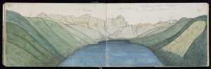
Illustration by Johann Franz Julius von Haast of extensive fern cultivations (light foreground) at Rotoroa, 1860. Haast, Johann Franz Julius von, 1822-1887. Haast, Johann Franz Julius von, 1822-1887: Rotoroa, Mount MacKay, Humbold Chaine. 25 Januar 1860. Haast family: Collection. Ref: A-108-034. Alexander Turnbull Library, Wellington, New Zealand. /records/22680353


Ethnographer Elsdon Best noted in 1902 that aruhe from these inland areas was much better than that harvested from the coast. Before it could be eaten, aruhe required a lot of preparation and was often mixed with plant extracts and additives to make both sweet and savoury dishes.

In the Ngāti Apa ki te Rā Tō Deed of Settlement there is a clause that recognises our unique connection to both Rotoroa and Rotoiti and the tuna within, and allows us to harvest tuna for special cultural hui.

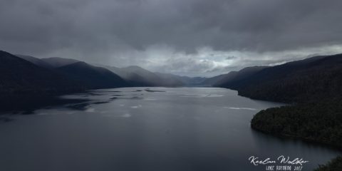
This short film by Keelan Walker documents whānau as they embark on their annual customary tuna harvest from at Rotoroa.

More Information»
All Listing Types All Locations Any Rating

Listing Results

  • Te Matau-a-Māui (Separation Point)

    Te Matau-a-Māui (Separation Point)

    Cultural Redress, He Tangata (People), Mahinga Kai, Wāhi Tapu

    Read more
  • Moutere Inlet 

    Moutere Inlet 

    Cultural Redress, Mahinga Kai, Wāhi Tapu

    Read more
  • Matangi Āwhio (Auckland Point) 

    Matangi Āwhio (Auckland Point) 

    Cultural Redress, He Tangata (People), Mahinga Kai

    Read more
  • Kawatiri (Buller)

    Kawatiri (Buller)

    He Tangata (People), Mahinga Kai, Wāhi Tapu

    Read more
  • Kawatiri (Buller) River and its tributaries

    Kawatiri (Buller) River and its tributaries

    Awa | Rivers, Cultural Redress, He Tangata (People), Mahinga Kai, Wāhi Tapu

    Read more
  • Tākaka River

    Tākaka River

    Awa | Rivers, Cultural Redress, He Tangata (People), Mahinga Kai, Wāhi Tapu

    Read more
  • Te Motupiko (Motupiko River)

    Te Motupiko (Motupiko River)

    Awa | Rivers, Cultural Redress, He Tangata (People), Mahinga Kai

    Read more
  • Te Waimea (Waimea River)

    Te Waimea (Waimea River)

    Awa | Rivers, Cultural Redress, He Tangata (People), Mahinga Kai, Wāhi Tapu

    Read more
  • Toropuhi

    Toropuhi

    He Tangata (People), Mahinga Kai, Wāhi Tapu

    Read more
  • Patuarau

    Patuarau

    He Tangata (People), Mahinga Kai, Wāhi Tapu

    Read more
  • Parapara (Parapara Inlet)  

    Parapara (Parapara Inlet)  

    He Tangata (People), Mahinga Kai, Wāhi Tapu

    Read more
  • Pākawau

    Pākawau

    He Tangata (People), Mahinga Kai, Wāhi Tapu

    Read more
  • Pūponga

    Pūponga

    He Tangata (People), Mahinga Kai, Wāhi Tapu

    Read more
  • Whanganui Inlet

    Whanganui Inlet

    He Tangata (People), Mahinga Kai, Wāhi Tapu

    Read more
  • Westhaven Wildlife Management Reserve 

    Westhaven Wildlife Management Reserve 

    Cultural Redress, He Tangata (People), Mahinga Kai, Wāhi Tapu

    Read more
  • Te Taitapu (Westhaven) Marine Reserve 

    Te Taitapu (Westhaven) Marine Reserve 

    Cultural Redress, He Tangata (People), Mahinga Kai, Wāhi Tapu

    Read more
  • Te Taitapu (Big River site)

    Te Taitapu (Big River site)

    He Tangata (People), Mahinga Kai, Wāhi Tapu

    Read more
  • Te One Tahua (Farewell Spit)

    Te One Tahua (Farewell Spit)

    Mahinga Kai, Wāhi Tapu

    Read more
  • Kaiteriteri Scenic Reserve 

    Kaiteriteri Scenic Reserve 

    Cultural Redress, He Tangata (People), Mahinga Kai, Wāhi Tapu

    Read more
  • Te Taero a Kereopa (Boulder Bank) 

    Te Taero a Kereopa (Boulder Bank) 

    Mahinga Kai, Wāhi Tapu

    Read more
  • Tarakaipa Island

    Tarakaipa Island

    Mahinga Kai, Te Taiao, Wāhi Tapu

    Read more
  • Puhikererū (Mt Furneaux) 

    Puhikererū (Mt Furneaux) 

    Mahinga Kai, Ngā maunga | Mountains, Te Taiao, Wāhi Tapu

    Read more
  • Te Anatohia (East Bay) 

    Te Anatohia (East Bay) 

    Mahinga Kai, Wāhi Tapu

    Read more
  • Te Ope-a-Kupe (Te Anamāhanga/Port Gore) 

    Te Ope-a-Kupe (Te Anamāhanga/Port Gore) 

    He Tangata (People), Mahinga Kai, Mana Rangatahi, Ngā maunga | Mountains, Wāhi Tapu

    Read more
  • Rotoiti

    Rotoiti

    Mahinga Kai, Ngā Roto | Lakes, Te Taiao, Wāhi Tapu

    Read more
  • Rotoroa

    Rotoroa

    Mahinga Kai, Ngā Roto | Lakes, Te Taiao, Wāhi Tapu

    Read more